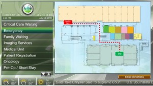
Building Interactive Maps Easily
Gail Chiasson, North American Editor
X2O Media, Montreal-based full-service provider of software, network management, and content services for professional digital signage applications, has launched a new Microsoft PowerPoint add-in that greatly simplifies the content creation process, allowing users to build their own wayfinder maps for corporate facilities, campuses, airports, public venues, and more.
 With the new wayfinder add-in, users of X2O’s Xpresenter digital signage platform can easily import floor plans and create digital, interactive wayfinder maps — with start and end points and animated directional arrows that indicate the path — directly inside PowerPoint and then publish them to the X2O network. The maps can include a video or an image for both start and end points, and on-the-go signage viewers can even email directions to themselves directly from the interactive screen.
“Our wayfinder maps have been an extremely popular feature in a number of X2O networks, from hotels and conference centers to casinos and airports, and we can now offer this cost-saving tool to our customers on a mass scale,” says David Wilkins, X2O Media’s president and CEO. “Xpresenter users are already creating a wide variety of graphics and other content for their networks with our PowerPoint-based Xpresenter Template Maker authoring module, and now they can easily create these wayfinder maps as well, saving content managers considerable time and reducing the need to learn new tools and applications.”
X2O Media’s Xpresenter is an end-to-end platform designed to make creating, managing, and distributing broadcast-quality digital signage content on networks of all sizes available to all. Its patented authoring module allows Microsoft PowerPoint users to produce compelling graphics that incorporate animations, smart objects, video clips, and real-time data sources — all without ever leaving the PowerPoint interface.

July 27th, 2010 at 17:22 @765
This seems like a great fit for those 10 – 15 unit small business centers. Its a dynamic replacement for those little plastic letters and numbers that usually mean you’ve entered the dentist or doctor’s office…visitors will at least be less nervous.
As long as the person in the company tasked with mapping isn’t too highly paid (wasting their time in PPT) or too underpaid (not familiar with advanced animation features in PPT), this can service a great need.
Well done X20. Mapping shouldn’t break the bank!